Wednesday, March 31, 2021

Geology Through Literature - Han Christian Andersen's: Beautiful

Geology Through Literature: 

Hans Christian Andersen's: Beautiful (1859)


For the fourth entry we continue on through Hans Christian Andersen's oeuvre to our next geological reference.

For other Geology Through Literature entries, please check them out compiled on my website.

Beautiful (1859)

Eruptions

It was a delight to hear Mr. Alfred speak. He told them of Naples, of trips to Mount Vesuvius, and showed them colored prints of some of the eruptions. The widow had never heard of such things before, much less taken time to think about them.

"Mercy save us!" she said. "So that's a burning mountain! But isn't it dangerous for the people who live there?"

"Entire cities have been destroyed," he answered. "For example, Pompeii and Herculaneum."

"Oh, the poor people! And you saw all that yourself?"

"Well, no, I didn't see any of the eruptions shown in these pictures, but I'll show you a drawing I made of an eruption I did see."

He laid a pencil sketch on the table, and when Mamma, who had been studying the highly colored prints, glanced at the black-and-white drawing, she cried in amazement, "When you saw it did it throw up white fire?"

For a moment, Alfred's respect for Kala's mamma nearly vanished; but then, dazzled by the light from Kala, he decided it was natural for the old lady to have no eye for color. After all, it didn't matter, for Kala's mamma had the most wonderful thing of all—she had Kala herself.

We head back to Mount Vesuvius, as we talked about previously with the What the Moon Saw story. The only thing to add here of note was that Herculaneum was also well known by this time, with the excavation actually having started before the excavation of Pompeii in 1748. Herculaneum itself was discovered after Pompeii, in 1709, and systematic excavation beginning in 1738, a full decade before Pompeii. The note in the text about Mr. Alfred showing Mamma the "colored prints", I must assume that he means copies of colored paintings and drawings, since colored photography had yet to be invented. 

Vesuvius in eruption, April 26, 1872. Original caption 'from a photograph taken in the neighbourhood of Naples''. (Palmieri and Mallet, 1873). Image courtesy of Oxford Sparks

However, an interesting note is that the first photograph of a volcanic eruption is believed to be the 1972 eruption of the very same Mount Vesuvius, which aided the Director of the Vesuvius Observatory, Luigi Palmieri, to document the eruption with a dramatic line drawing. 

References

Tuesday, March 30, 2021

Geology Through Literature - Han Christian Andersen's: Ole The Tower Keeper

Geology Through Literature: 

Hans Christian Andersen's: Ole, The Tower Keeper (1859)


For the third entry we continue on through Hans Christian Andersen's oeuvre to our next geological reference.

For other Geology Through Literature entries, please check them out compiled on my website.

Ole, The Tower Keeper (1859)

First Visit
Listening to the Rocks
Among the books I had recently lent Ole was one about pebbles, which had greatly pleased him.

"They are truly veterans from olden times, those pebbles," he said, "yet people pass them by without thinking, and trample them down in fields or on beaches, those fragments of antiquity. I have done so myself. From now on I shall hold every paving stone in high respect!...

"The romance of the Earth is truly the most fascinating of all romances. It's a shame we can't read the first parts of it; but they're written in a language we haven't learned yet; we have to dig away among strata and rocks, puzzling out bits here and there from the early acts of earth's drama.... The crust on which we move remains solid so that we never fall through, and so it is a story of millions of years, with steady progress. 

"Many thanks for your book on pebbles; those old fellows could tell us so much if only they could talk.... And it makes you feel so ridiculously young, compared with the millions of years of these venerable stone!"

"...I was rolling through millions of years with my rocks, watching them break loose up in the North, drift along on icebergs ages before on a reef, and at last peer up through the water and say, 'This shall be Zealand!'..." 

What Andersen is describing is exactly what geologists hope to decipher. Geologists read the rocks. They listen to what the rocks have to say and have been doing it far before Andersen's time period. Which he should be aware of with his comments about the earth being millions of years old, since geologists are the reason that we even thought that the earth was millions of years old at that time (we now know it to be ~4.543 billion years old).  

Layers of the Earth

The scientist that is often touted as the father to modern geology is James Hutton, who lived from 1726 to 1797. He is the one who came up with some of the first principles of geology, which are his way of essentially listening to what the rocks had to tell us. James Hutton's primary theory that he developed was the Principle of Uniformitarianism, which stated that the present is key to the past and that all processes happening on Earth today are the same ones that happened on the Earth in the past. This means that when we have ripples and mud cracks in modern day sediments, they can help us identify ripple marks and mud cracks in the rock record. Since everything happening today has happened in the past and erosion and deposition are incredibly slow processes then the age of the Earth must be very, very old. Although he couldn't be sure of an exact age of the Earth, one could easily assume the Earth was millions or even billions of years old based on the rates of modern day erosion and sedimentation.

His research continues today with geologists "reading the rocks" and listening to their life stories. Then taking this information and combining it with the histories of other rocks, until we have a full and complete global history dating back to the beginning of the earth. We aren't fully there yet, and we may never get fully there, but it is an ever hopeful promise that we may.

Shooting Stars

"Then three or four beautiful shooting stars fell; they shone brightly, and started my thoughts off in an entirely different direction. Does anybody know what a shooting star really is? The learned do not know!..."

Although Andersen claims that the "learned do not know", we do know today what they are. They are bits of cosmic debris that burns up when it enters our atmosphere, technically called a meteor. The meteor is the flash of light that we see when the debris enters the atmosphere and the debris itself is called a meteoroid. 

Illustration of a "fireball" from a 1771 publication by Le Roy (Marvin, 2007). 

What interests me about this statement is when did scientists begin to learn about meteors and shooting stars. One of the first scientists to suggest that the fireballs were real events was Ernst Chladni in 1794. He hypothesized that shooting stars, fireballs that came crashing to earth, and the physical meteorites were all related phenomena. Although there was resistance to the idea at the time, he persevered until his death in 1827. It was not until 1834, that scientists had been able to start piecing together that meteor showers were tied to specific orbital events, and from here to realize that shooting stars were actually pieces of orbiting materials burning up in the atmosphere. 

It took until 1862 when the hypothesis that shooting stars had an extraterrestrial origin had firmer proof with the prediction and the tying of comets to specific orbits and times of the year. With these observations, future meteor showers were able to be predicted including the 1866 Leonid shower. So, even though the story was written in 1859, there still was significant evidence at that point that meteoroids were the cause of the shooting stars with firmer proof only a few years away.  

References

Monday, March 29, 2021

Geology Through Literature - Han Christian Andersen's: What the Moon Saw

Geology Through Literature: 

Hans Christian Andersen's: What the Moon Saw (1839-1840)


For the second entry we continue on through Hans Christian Andersen's oeuvre to our next geological reference.

For other Geology Through Literature entries, please check them out compiled on my website.

What the Moon Saw (1839-1840)

Twelfth Evening
Mount Vesuvius
"I shall give you a picture of Pompeii," said the Moon. "I was outside the city, in the Street of the Tombs, as they call the place where happy youths, with wreaths of roses on their heads, once danced with the fair sisters of Lais. Now the silence of death reigns there.

"German soldiers in the service of Naples kept guard, and played cards and diced. A group of strangers from beyond the mountains walked into the city, conducted by a guard. They had come to see, in the full clear rays of my light, the city arisen from the grave. I showed them the ruts of the chariot wheels in the streets paved with great slabs of lava. I showed them the names upon the doors and the signs still hanging before the houses. In the narrow courts, they saw the fountain basins ornamented with shells, but the waters no longer spouted forth. No longer were songs heard from the richly painted chambers, where the bronze dogs kept watch before the doors. It was the City of the Dead. Vesuvius alone still thundered his eternal hymn, and each stanza of it men call a new eruption. We visited the Temple of Venus, built of pure white marble, with its high altar in front of its broad steps; the weeping willow has sprung up between the columns. The air here was transparent and blue, and in the background loomed Vesuvius, black as coal, its flames rising straight as the trunk of a pine tree. The glowing smoke cloud lay in the still calm of the night like the crown of the pine tree, but red as blood."

As is relatively well known, the city of Pompeii, located 14 miles to the southeast of Naples, was buried in ash after the eruption of the volcano Mount Vesuvius in 79 AD. This eruptive cloud of  heated gasses, ash, and other pyroclastic debris asphyxiated the populace and buried it in ash, preserving the town, and the people, to this day. As noted in the text, even the ruts in the streets were preserved. 

The street Via dell'Abbondanza in Pompeii with the street car ruts visible. Image courtesy of Britannica.

The city itself was also built on top of lava flows, being located very close to the volcano. Vesuvius, although not historically active prior to 79 AD, is a very active volcano. The people of Pompeii and surrounding towns likes Herculaneum were unaware of the danger that they were in but just being in the vicinity of the mountain. That time has passed and now people are fully aware of the hazards in the area, many of those from the repeated eruptions of Vesuvius since 79 AD. 

The ruins of Pompeii were discovered in the late 16th century with excavation work on the city beginning in 1748 under the patronage of the king of Naples, Don Carlos, carried out by the military engineer Karl Weber. During this time, the excavations were haphazard and often by untrained treasure seekers. 

As noted in the excerpt, these excavations took place in the shadows of eruptions by Vesuvius, with eye witness accounts describing the very same pillar of fire erupting from the volcano itself during this time. Between the time the excavations started (1748) and the time the story was published (1840), there were 7 separate periods of volcanic activity, with several containing "pillars of flame". The most recent one to the publication in January of 1839 had this event described: 
Outflow on 31 Dec 1838. At dawn of 1 Jan 1839, dark eruption column, lava flow to W . Between 1 and 4 Jan, fracture of the cone to E and W, on 2 Jan high white cloud; then lava to E (Boscotrecase) and W (Canteroni); lava fountains up to 400 m, and black ash on Boscotrecase and Castellammare. After the eruption the crater was funnel-shaped with a diameter of 700 m and a depth of 285 m (Pilla, Baratta) (Courtesy of MTU.edu)

And not only are there written descriptions, but visual recreations in the forms of paintings from the time. Below are  pictures of eruptive columns from the 1788 eruption and the 1822 eruption.

Vesuvius from Posillipo by Joseph Wright of Derby, painted ~1788. Image courtesy of Wikipedia.

Vesuvius in eruption, October 1822. George Poulett Scrope, Considerations on Volcanoes, 2nd ed. (1864), frontispiece. Image courtesy of the BBC.

So, it would appear that Andersen was very well informed with the geological activity going on during his time.

References

Sunday, March 28, 2021

Geology Through Literature - Han Christian Andersen's: The Galoshes of Fortune

Geology Through Literature: 

Hans Christian Andersen's: The Galoshes of Fortune (1838)


Despite this not being my favorite book I ever read, or even anywhere near an enjoyable book, there were actually quite a bit of geological references sprinkled through Andersen's publishing history. Andersen was also fairly accurate in a lot of his geologically descriptive passage that are still accurate to this day, even almost 200 years later. Since there are so many geological references throughout his fairy tale career, I have decided to do a post for each one that I am going to cover. 

For other Geology Through Literature entries, please check them out compiled on my website.

The Galoshes of Fortune (1838)

Part III. The Watchman's Adventure
The Speed of Light
"But all this is like the gait of a sloth, or the pace of a snail, in comparison with the speed of light, which travels nineteen million times faster than the fastest race horse.... The sunlight takes eight minutes and some odd seconds to travel nearly one hundred million miles."

The speed of light has currently been measured to be 3 x 10^8 meters per second (or more accurately 299,792,458 m/s). 

The maximum speed of a race horse is ~44 miles per hour, or ~0.122 miles per second.

Converting, the speed of light is therefore ~670,000,000 miles per hour, or ~186,000 miles per second.

The speed of light then works out to ~15 million times the speed of the fastest race horse. Of course you must take into account that perhaps the fastest race horse of today is not the same as the ones in the mid-1800's. So if you had a race horse with a top speed of 35 miles per hour, then indeed, the speed of light would be 19 million times faster.

My big question here though, was when was the speed of light determined? This story was published several decades before Einstein, so who discovered how fast light moves and how?

The speed of light was actually determined almost 350 years ago. In 1676, the Danish astronomer Ole Roemer was studying Jupiter's moon Io. By studying the length of the eclipse during different times of the year, Romer hoped to determine an accurate orbital period of the moon. The orbital period, determined to be 1.769 Earth days, was watched by Romer over many years and he noticed that the time intervals between eclipses wasn't consisted. As the Earth moved towards Jupiter, the eclipses came earlier. As the Earth moved away from Jupiter, the eclipses came later. He estimated that there was a difference of 22 minutes between the two extremes. The cause of this delay, he determined, was the time that the light needed to cross space from the closer orbital point to the further orbital point. Dividing this time by the diameter of Earth's orbit, should give a fairly accurate value for the speed of light.

Illustration of how Romer determined the speed of light from the time of Io's eclipse. Image courtesy of AMNH by Diana Kline

This calculation was done by Dutch scientist Chistiaan Huygens, finding the value to be 131,000 miles per second (off by about 30%). The difference from the true value was due to inaccuracies in the time calculation by Romer (actually 16.7 minutes, not 22) and imprecise knowledge of the Earth's orbital diameter. Even with the incorrect speed determined, he was at least within the correct ballpark and his method for determining the speed of light was accurate.

The Moon

In a few seconds the watchman took in his stride the 260,000 miles to the Moon. As we know, this satellite is made of much lighter material than the earth, and is as soft as freshly fallen snow. The watchman landed in one of the numerous mountain rings that we all know from Doctor Maedler's large map of the Moon.

The novel Vanity Fair, happened to also bring up the topic of the distance to the moon and was published about 10 years after this book. I had broken down the early history of how the distance to the moon was calculated there

For here I wanted to focus on three things. The first is the assumption here that the moon was made of a much lighter material than the Earth. We now know that the moon not made of softer and lighter stuff than the Earth, it is actually made of the same rocks as the Earth, and that is because it was formed from the Earth. Early in the history of the Solar System, there was a proto-Earth and another planet known as Theia. Theia crashed into Earth in its early history, melting both planets and combining them into one with a much smaller mass spinning off to form the moon. Because of this, chemically speaking, the moon is identical to the Earth. However, over time as the Earth has aged, it's rocks have differentiated from each other to produce varying rock types in different environments and depths, whereas the moon, being far smaller, cooled far quicker and is a much more homogenous mass. 

The second question brought up is, is the surface of the moon really as soft as snow? The surface of the moon has been under constant bombardment of meteoroids that have been pummeling the lunar surface for nearly the entire 4+ billion history of the moon, leaving behind a layer of rock dust. It was even thought that the first people to land on the Moon in Apollo 11 could potentially sink right into the lunar soil because of this dust. That however, did not happen, since even though there is a fine layer of dust over the entire moon, the rocks, dust, and other debris have compacted over time just below the surface, providing a firm surface to stand, and land, on.

Copy of Mädler's original 1834 moon map. Image courtesy of  Worthpoint.

And the third thing is the map of Doctor Maedler. It turns out that shortly before this short story was written, that the first lunar map was published in 1834 by Johann Heinrich von Mädler. Originally broken up into four smaller section, it was eventually combined together into one very large map by 1837. This map gave us our first detailed, and widely available, map of the moon.

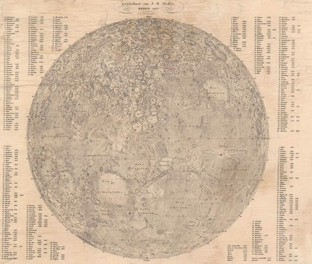
Mädler's 1837 version of the Moon map. High resolution version available at Geographicus.

So it turns out there actually was a highly detailed map of the moon as described by Andersen that could be used as a scientific basis for fictional landing sites. 

References

Wednesday, March 24, 2021

Neoichnology - Beetle Traces in the Sand

Ichnology is the scientific study of traces and traces of animals, specifically these tracks and traces are typically preserved in the geological rock record. I go into depth on what exactly is a Trace Fossil in a previous post. 

Neoichnology is the scientific study of tracks and traces in modern sediments, made by currently extant (living) organisms. Scientists, specifically ichnologists, biologists, geologists, and paleontologists, will look at modern traces in order to better understand fossil traces. 

As someone who is an ichnologist by training, I am fascinated by the traces left behind by both modern and ancient organisms and I will frequently find myself taking pictures of tracks and traces left behind in various substrates. While on vacation in central Utah, at Yuba State Park, I came across one such series of interesting traces within the sand dunes of the park.


Trace fossils, like regular fossils, are also named based on their morphology. That means different traces will get an ichnospecies and an ichnogenus (just like an animal is identified by its genus and species). Modern day traces, although not technically trace fossils, can often be tied back to traces in the rock record. So, for these tracks we can identify an ichnogenus and an ichnospecies for them just as if they were trace fossils. For the trace above it would most likely be identified as Lithographus (as the ichnogenus). [Thanks to Simon Braddy and Patrick R Getty on the Ichnology Facebook group for help with the diagnosis.] Taxonomic classification of trace fossils (inchnotaxonomy) has a defined set of characteristics known as a diagnosis for each particular ichnogenus and ichnospecies. The classification diagnosis for the ichnogenus Lithographus is as such (according to the emended diagnosis of Minter and Braddy, 2009) :
Trackways consisting of staggered to alternating series of up to three tracks, at least one of which is linear to curvilinear, whilst they may also be ovoid or crook shaped. The tracks in a series have different orientations. The longest track is parallel to slightly oblique to the mid-line of the trackway and is either the middle or the inner track. The shortest track is orientated antero-laterally, or parallel, to the mid-line and is either the inner or the middle track. The middle-sized track is generally orientated perpendicularly to the mid-line but can also be orientated postero-laterally or antero-laterally. Straight or sinusoidal single or paired medial impressions may also be present.


Trace fossils in the rock record are also nearly impossible to definitively attribute to a specific animal, unless that animal was physically located in connection to the trace. Often times the maker of a trace fossil can be fairly accurately assumed based on the morphology of the trace and the morphology of animals living at the time and in the same region as the trace fossil. Dinosaur footprints often fall into this category, where specific footprint morphologies can often be tied back to a potential maker. Other times it is completely unknown who made a trace fossil. In modern day traces, it is often much easier to accurately identify the trace maker, since we can often find them making the trace, or at least nearby. As in this case, upon closer inspection, we can actually see the trace maker making the traces. It turns out that these traces were left behind by the beetle seen in the photo, the Ten-lined June Beetle (Polyphylla decemlineata). 

The Ten-lined June Beetle (Polyphylla decemlineata). Image courtesy of Bug Guide.

The Ten-lined June Beetle is a fairly common beetle found across western North America with verified occurrences from Nebraska west to the Pacific Ocean, and California north into Canada.

Verified Ten-lined June Beetle occurrences according to Bug Guide.

And of course, as any good scientist would do, I wouldn't want a picture of a trace without a scale bar. And since I didn't have a scale bar with me at the time, my flipflop stood in for reference.


References
https://bugguide.net/node/view/23563/data

Wednesday, March 10, 2021

Elementary Paleontology Education - Did Dinos Drag Their Tails

Coming home from school a couple of years ago (3rd grade), my daughter had some work to do in her Reading textbook. Looking over the questions, I was rather appalled by the implication that they had in this book that still persist to this day.


The question in question is number 15: "Write the letter of the part that shows the mark left by the animal's tail."

Analyzing the traces in the image above, the footprints indicate that we are likely dealing with a large theropod dinosaur, based on the shape of the foot. These three-toed impressions looks similar to a Tyrannosaurus rex or a Dilophosaurus footprint. Within the image above we can not entirely differentiate between the two because we don't have a scale to identify the size of the footprints. There are also other dinosaurs that make three-toed footprints. These include the ornithopods (like Parasaurolophus and Hadrosaurus), however their footprints are generally more rounded in nature, with less toe definition. 

Since these are likely theropod footprints, lets look at the anatomy of a theropod dinosaur. Science has basically determined that these large theropod dinosaurs walked as sort of a lever, with the hip joint working as a fulcrum. You have the front half of the dinosaur, with the head and arms on one side of the hips, laid out perpendicular to the legs, and the tail sticking straight out behind the dinosaur, also perpendicular to the legs. And if you look at the illustration given in the reading textbook, this is actually almost what is shown.


Although this is a more upright version of what this type of dinosaur looked like, it was likely closer to reality than what they were implying with the tail drag question. And even looking at the dinosaur pictured, there is no way that that dinosaur is even dragging its tail. There is a complete disconnect between the pictured animal and what the traces that it left behind indicate. Based on the size, shape, and number of fingers of the animal pictured, this is likely a Tyrannosaurus rex. And we can look at historical and modern interpretations of what the animal may have looked like.

Original mount for the Tyrannosaurus rex by Barnum Brown at the American Museum of Natural History. Image courtesy of Benjamin Burger

Looking at the original mount for the T. rex above, we can clearly see that this animal looked like it dragged its tail. However, for Barnum Brown to even get the skeleton to bend like this he had to break some of the vertebrate. Which, any modern day scientist will tell you, if you need to break the skeleton to do what you want it to do, you are doing something wrong.

As mentioned above, the modern day interpretation of the T. rex stance is much more of a lever and fulcrum situation as can be seen on SUE below from the Chicago Field Museum.

SUE the T. rex from the Chicago Field Museum.

The modern interpretation of the T. rex stance clearly did not drag its tail. I can't even imagine how this animal would have gotten its tail on the ground.

Other potential tail dragging dinosaurs?

The question then comes that if theropod dinosaurs didn't drag their tails, did any dinosaurs? And the answer to that is a "not usually, but maybe at times?" There have been some indications of tail dragging by dinosaurs in the fossil record, however these are by non-theropod dinosaurs, with the most obvious one being tied to a sauropod (Foster et al., 2000). Foster et al. describe a sauropod trackway that shows evidence of a midline tail drag mark from Twentymile Wash within the Grand Staircase-Escalante National Monument, preserved within the Middle Jurassic aged Entrada Sandstone. 

However, besides this one instance, there are numerous dinosaur trackways preserved around the world with the number of tail drag traces almost nonexistent. There has been a few others tail drag traces mentioned in the literature, which have been attributed to sauropods and ornithopods, however the identification of tail drag in some of these cases were ambiguous and uncertain. So, although it is possible that some dinosaurs may have been dragging their tails, it is far from common place, and more of an abnormality than anything consistent.

What if this trace was real?

But thinking like a scientist, and knowing what we know about modern T. rex anatomy, if we did come across the trace fossils as seen above (the footprints and tail drag), how would it be classified. We can narrow this down to several possibilities:
  1. This is a true tail dragging theropod. 
    • If this were the case, it would likely be due to an injury that the animal sustained, causing it to drag its tail. An anomaly that we haven't currently found in the fossil record, but one that cannot be ruled out.
  2.  The animal itself was carrying something that was dragging along the ground.
    • This is the theory that I like to think makes the most sense. Suppose the animal had its dinner and was carry part of it back to its home or somewhere else. With little use of its arms, its mouth and legs would provide most of the functions that it would need to carry and tear apart any meat. Therefore, it is possible that a large enough body of meat would drag along the ground while being carried by the theropod.
  3. Something else made the drag mark.
    • There are numerous animals that do drag their tails, specifically reptiles, lizards, and other small animals. Although it is a possibility that a theropod came along and walked along the other animals footprints, essentially erasing them, while preserving the tail drag, this is an extremely unlikely scenario. It is also possible that is was a natural drag mark, perhaps a stick being floated down a river that drags along the riverbed. However, again it is unlikely that any animal would walk with this drag mark perfectly aligned between the footprints. 
So with the evidence displayed above, which is a set of theropod footprints and a groove aligned medially between them, I think the most likely scenario to produce such a trace would be the dragging of something, likely food, by the large theropod dinosaur. That would make this most likely a drag trace and not a tail drag trace.

Thursday, March 04, 2021

Geologic State Symbols Across America - Illinois

The next state up for the Geological State Symbols Across America is:


Illinois


You can find any of the other states geological symbols on my website here: Dinojim.com (being updated as I go along).

                                                                                       Year Established
State Mineral: Fluorite                                                                     1965
State Fossil: Tully Monster                                                               1989

-------------------------------------------------------------------------------------------------------------
State Mineral: Fluorite
5 ILCS 460/25
from Ch. 1, par. 2901-25

Sec. 25. State mineral. The mineral calcium fluoride, commonly called "fluorite", is designated the official State mineral of the State of Illinois.

Source: P.A. 90-655, eff. 7-30-98.
Fluorite crystal from Chicago. Crystal is displayed at Chicago's Field Museum

Fluorite (sometimes called Fluorspar) is a mineral that is part of the halide family and is composed of calcium and fluorine (CaF2). Named after the Latin word fluere, meaning "to flow", fluorite was frequently used as a flux, due to its ability to easily melt. Fluorite has a couple of diagnostic properties that make it very easy to identify. It is translucent or transparent, and is the only common mineral to have four directions of cleavage. The cleavage, which is the ability to break along specific planes of weakness, causes it to produce an octahedron shaped crystal (i.e. two pyramids attached to each other at the base, as seen in the image). In addition to a low melting point, it is also a fairly soft mineral, being used to denote the hardness of 4 on Mohs Hardness Scale. Fluorite can be found in a wide variety of colors including purple, green, yellow, blue, pink, and brown, however fluorite has a special property in that it fluoresces under a black (UV) light. This means that it glows, a process that, when discovered, was named after the mineral fluorite. Fluorite is formed when hydrothermal fluids flow through limestones, dolostones, and other rocks depositing not only fluorite minerals but also frequently metallic ores including tin, silver, lead, zinc, and copper. Fluorite has a lot uses, making it a valuable ore, the primary use of which is as a source for the element fluorine. From its namesake, Fluorite has been used as a flux for steel production, helping to remove impurities from the melt. In chemical applications, it is used to manufacture hydrofluoric acid (HF), which then can be used to create fluorocarbon chemicals, foam blowing agents, refrigerants, and a variety of fluoride chemicals. It is also used to manufacture specialty glass, ceramics, enamelware, the Teflon coating, optical lenses, or even just as a gemstone. Most of the fluorite in the US has been mined out with the last mines closing in 1995 due to low production and cheaper sources elsewhere. Otherwise, most of the fluorite used in the US is imported from China, Mexico, Mongolia, and South Africa.

Geologic map of the Illinois-Kentucky Fluorspar Mining District. Image courtesy of the USGS.


Fluorescing of Fluorite crystals at Chicago's Field Museum

The area where the fluorite is found within Illinois is mainly in Hardin and Pope Counties, however the region also extends into Kentucky, encompassing an area known as the Illinois-Kentucky Fluorspar Mining District. Initially, this area was mined for the related lead deposits starting around 1835. Fluorite was initially thought to be worthless and therefore was disposed of in order to get to the more valuable and related minerals. However, once the value of fluorite had been recognized in the later 1800's as a flux, more attention was paid to mining it. From 1880 to 1976, this region had produced ~9.5 million tons of ore, 80% of the total US production. The region where the fluorite is being mined was a depositional basin back in the Paleozoic, specifically the Mississippian (~330 million years ago), when the host rocks were laid down. The host rocks, specifically the upper part of the Meramecian and the lower part of the Chesterian Series are predominantly limestones, with some sandstones and shales interbedded. The noted Bethel Sandstone on the legend of the map above represents the near base of the Chesterian Series of rock units. The Meramecian limestone beds, made up predominantly of the shells of marine organisms, were laid down in a near-shore/continental shelf marine environment. The deposition of the Bethel Sandstone beds marks a transition from mostly marine limestone to more near shore clastics like sandstone and shale deposits. Later this region was inundated with northeast to southwest running faults, as can be seen on the map above. These faults allowed for the transmission of Jurassic Age (~175 million years ago) hydrothermal fluids, which were related to nearby volcanic activity. These hydrothermal fluids, rich in the element fluorine, mixed with the calcium rich limestones to produce abundant deposits of fluorite, along with many other valuable ore minerals. Although the majority of fluorite in the US has come from these deposits, eventually cheaper sources of fluorite from outside the country as well as dwindling reserves forced many of the mines to shut down in the late 1980's. In December of 1995, the last of the Illinois fluorite mines closed. The over abundance of Illinois fluorite specimens kept the price of Illinois fluorite fairly steady until around 2009, when the price started to steeply increase. Today it costs ~10 times as much for an Illinois specimen of fluorite than it cost back in the early 1990's. 

State Fossil: Tully Monster
5 ILCS 460/60
from Ch. 1, par. 2901-60

Sec. 60. State fossil. The fossil Tullimonstrum gregarium is designated the official State fossil of the State of Illinois.

Source: H.B. 86-346
Tully Monster fossil from Illinois. Fossil is displayed at Chicago's Field Museum

The Tully Monster, formally named Tullimonstrum gregarium, is a rather bizarre fossil found in the Mazon Creek fossil beds of Illinois. The Mazon Creek is part of the Middle Pennsylvanian age (~309 million year old) Francis Creek Shale Formation. Located outside of Chicago, near Morris in Grundy County, the beds are shale interspersed with coal seams as well as siderite nodules. Siderite, also known as iron carbonate, forms from the interaction of seawater, mud, and organic matter of dead animals to cause layers of ironstone build up and harden around the dead organism. The nodules then survive through the ages as much of the shale is weathered away. Once broken open, the nodules will often reveal soft bodied organisms in tremendous detail, which are frequently not able to preserved in other forms of fossilification. The Tully Monster is one of these such organisms. 

Possible reconstruction of the Tully Monster, Tullimonstrum gregarium. Image courtesy of Wikimedia CC BY-SA


Tully Monster fossil from Illinois. Fossil is displayed at Chicago's Field Museum

The proximity of the coal seams to the iron nodules brought fossils collectors into the area when strip mining for coal began in the 1850's. The Tully Monster itself wasn't discovered until the late 1950's by Francis Tully, an amateur fossil collector. In 1966, it was named in honor of its discoverer with the name it was generally known as, the scientific version of "Tully Monster". And this fossil truly was a "monster". Not fitting into any of the known classifications at the time, the Tully Monster is unique to Illinois, being found nowhere else in the world. Over the past 70 years, several papers have come out describing what this organism actually is, with a 2016 paper describing the organism as a type of lamprey, a jawless fish. Some of the previous thoughts were that it could be a segmented worm or perhaps a swimming slug. As can be (kind of) seen in the fossil above, the animal was comprised of a torpedo shaped body, a jointed trunk-like snout that ended in a claw-like structure with teeth, and had eyes on the ends of a rigid bar extending sideways from the head. The identification of the possible presence of a notochord, placed the animal within the vertebrates. However, the ever winding story of the Tully Monster isn't settled yet. A 2019 study called into question previous studies, specifically what the eyes were made out of, placing it possible outside of the group of vertebrates. So, whatever the Tully Monster is, it is still a mystery and it is still weird.

References